
SpaceVee designs and produces remote Space and Time visualization products and services.
Uniquely, we make possible new and incredible visualization through visual barriers on Earth and in Space.
The Revelation begins . . .

Space Exploration
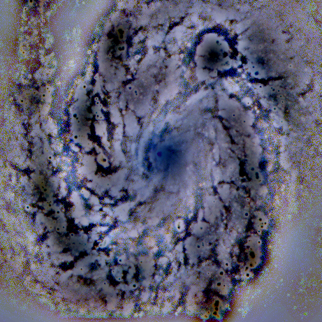
Mars’ surface and subsurface features after ERV processing by SpaceVee – (Original image by NASA/JPL. ). Martian surface has never been seen in such detail. We’ve recovered enhanced images of Io, Europa, Ganymede, Enceladus, Titan . . . Pluto . . . and we’re still going!
Now imagine doing all this elsewhere in the cosmos. The surface of an asteroid, Mars and Pluto, the cosmic gas and dust of galaxies, the oceans of Europa and Enceladus . . .
In Outer-Space – increased visibility beyond barriers anywhere with ERV.
Earth Exploration
Original Grand Canyon video link here
On Earth and in Earth-Space – increased visibility beyond barriers anywhere with ERV.
What We Do
We provide technologies and services that enable improved visibility through visual barriers on Earth, in Earth-Space and Outer-Space. Our technology core is ERV (Enhanced Remote Visualization). Perfect for aiding AI and Robotics vision systems for example.
Why We Do It
Wherever we explore beyond Earth and on Earth, what we see enables us to better function and make better situational decisions. Our drones, UAVs, robots, self-driving vehicles, AUVs and other autonomous machines require the same enablement. They are often required to work in low visibility situations. Sometimes they must work covertly or without emitting radiation. ERV works passively for this reason. Also, unlike ERV, X-ray and infrared imaging (such as thermal imaging) do not work or cannot be used in certain situations, for example under water or in foggy conditions. Additionally, as in the case of thermal imaging, the quality of images they produce cannot be used for visual navigation during flight. ERV enables this real-time super vision and retrospectively with images previously captured.
Our world is full of visual barriers because our natural visual ability is limited to the ‘visible’ radiation spectrum. This is a tiny part of the full spectrum of radiation that exists. Bees and some birds can see in UV, some fish, insects, bats and snakes can ‘see’ in Infrared.
SpaceVee expands our visual capability beyond barriers so that we can make better professional and situational decisions.
How?
As a product, we can integrate with your existing technology, device, equipment or exploration machine to deliver enhanced and subsurface remote visualization
As a service, we can take your photos and videos and enable actionable subsurface detail. Images taken by cameras such as in a planet or asteroid exploring robot, an airplane, sub-marine ROV, drone, UAV, satellite or pipeline inspection machine can be used.
In fact, any image taken by any digital imaging device can be used to recover real-time or historical subsurface and enhanced imagery.
You can use new and older images too. Great for pre-mission, post-mission and on-site real-time analysis. It also empowers autonomous decision-making by remote machines in flight, on the ground or underwater on Earth and elsewhere in Space.
What is a surface ?
From a visualization perspective, a surface prevents or reduces visibility beyond it. So a surface can be smoke, mist, fire, haze, soil, snow, cloud, gas, dust, etc. as well as the usual solid visual barriers. Our ERV technology based product and service can enable remote subsurface visualization.
‘When you see things differently . . . you think differently . . . then you discover’
SpaceVee founder.
Contact us to find out more.